

Click on a photo to enlarge it.
16.11.2003: Vermillion Cliffs - Bryce Canyon
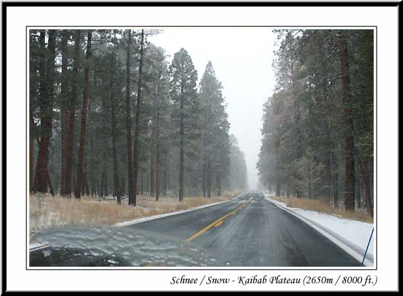
We had cinnamon rolls for breakfast and then drove passed the Vermillion Cliffs but coudn´t see much as it was so foggy! Then we drove up and up to 8,000ft above sea level and went to the visitor centre at the North Rim of the Grand Canyon. There was snow all around us and it was extremely cold! The road to the North Rim was closed at there was 8 inches of snow on it! After getting some information on Zion and Bryce National Parks we drove down to Kanab in Utah.
The weather forecast for the next few days in the two National Parks didn´t look very good at all. So we decided to change our plans and head for lower ground where it would be warmer. As we headed back across the state line into Arizona we realised that by heading for lower ground we would end up zig-zagging around and doing far more mileage. So we said "What the hell!" and turned around and headed for Bryce Canyon despite the weather!
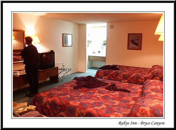
We drove up into the hills and to Bryce Canyon. It was still snowing and was very cold. The visitor centre had just closed and then we found that the only campground open, didn´t have showers as they were closed for the winter. And we needed a shower! There were also no hook ups so it would be really cold in Winnie. So we ended up getting a room at the Best Western Hotel called Ruby´s Inn! You have to have a bit of luxury from time to time!
The first thing we checked out was the indoor heated swimming pool!! And the Jacuzzi! It was like being on holiday!! Then we went for a meal in the restaurant. We´d actually been really looking forward to watching TV but there wasn´t anything interesting on - typical! We were extremely tired but needed to use the opportunity to work on the computer. It´s a hard life!
17.11.2003: Bryce Canyon - Kodachrome Basin SP
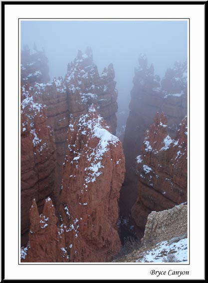
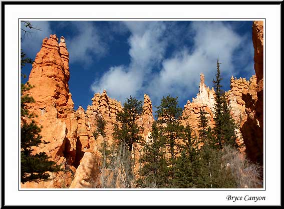
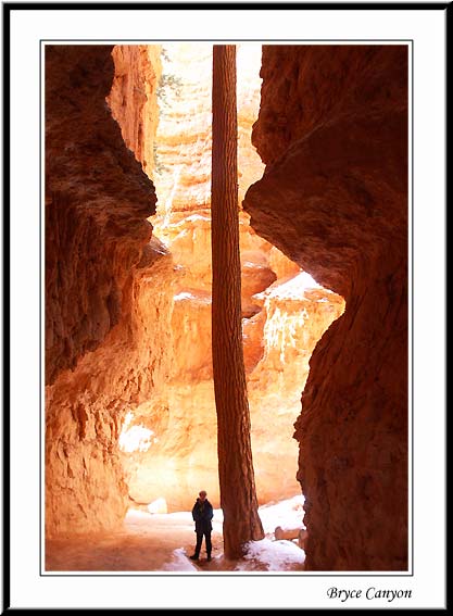
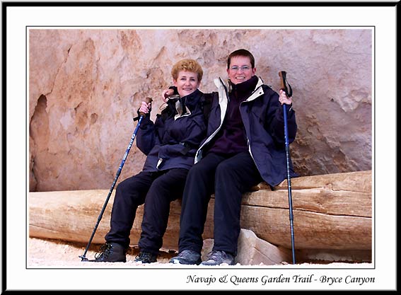
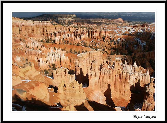
We got up at 9-30 am, showered, and whilst Kirsten worked on the computer, Helen went to fetch two hot chocolates to go with our doughnuts for breakfast! After checking out, we drove to Sunset Point and went for a snowy walk down into Bryce Canyon - a canyon surrounded by red pinnacle rocks. When the sun came out they shone like gold! Fascinating. We did a 3 mile hike along the Navajo and Queens Garden trails which was quite strenuous - well we are at 8,000ft!!
Then we drove to Bryce Point for a different view over the Canyon. We didn´t stay long as it was absolutely freezing in the wind. When we got to Winnie, Kirsten turned the key and nothing happened!! We looked at each other and then Kirsten tried turning the key again. Nothing, completely dead!! We were 7 miles from the nearest help and the car park was deserted except for us! Helen said " No Winnie, Please. Not now!"
We were just discussing the possibility of jump starting Winnie by attaching the jump leads from the back battery to the engine battery when Kirsten realised that Winnie was in reverse. When she put him into Park, he started without any problem! What a relief!! We laughed at how worried we´d been!!
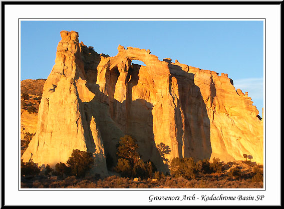
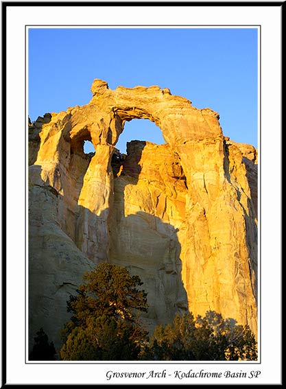
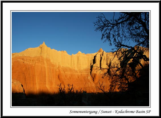
After apologising to Winnie, we drove back to Ruby´s Inn for lunch and shared a massive chocolate Brownie covered in hot fudge sauce, ice cream and cream! Then we drove about 40 miles along the scenic Highway 12 to Kodachrome Basin, a very scenic park. At the turn off to the campground, there was also the dirt road that leads to Grosvenor Arch which is recommended as seeing. Unfortunately, the dirt road is not recommended for Winnie! But we decided to risk going down it for the 10 miles to see the arch. It was extremely bumpy and we even had to ford a stream which Kirsten had to try out first to see if Winnie could make it!! It took us 1 hour to drive 10 miles! But it was worth it as we got there just as the sun was setting and the double arch looked impressive in the sun! A minute later the sun had set!
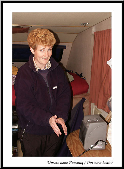
Of course, then we had to drive all the way back and by the time we got to the campsite it was pitch black! We decided to park right in front of the toilets as there was a plug there and plugged in our new heater we´d bought from Walmart! And it worked! We were going to be warm tonight!
As we had unexpected electricity, we baked potatoes in our oven and worked on the computer again. It was extremely windy outside, but we were snug as a bug in a rug!
18.11.2003: Kodachrome Basin SP
Got woken up at 7-30 am by the Ranger! That´s because we hadn´t paid as we didn´t have the correct change to put in the envelope and you don´t get any refunds! We don´t think he believed us when we told him! But we paid for 2 nights and he gave us change.
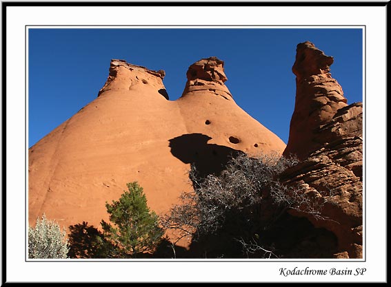
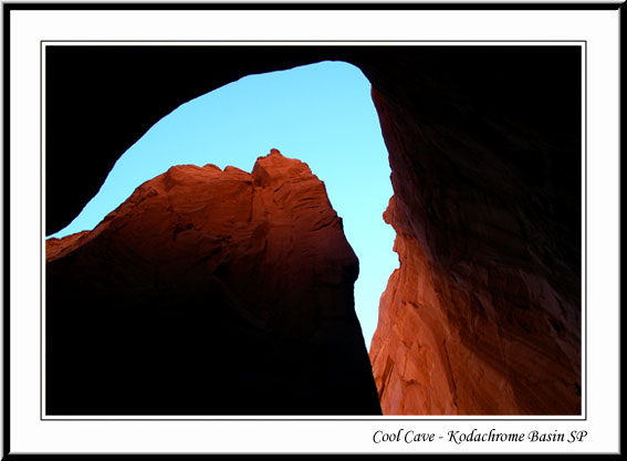
After a luke warm shower, we packed our rucksack and went off to do 6.5 miles hiking along Panorama, Big Bear Geyser and Cool Cave trails. It was sunny and warm and it wasn´t long before we were peeling off the layers. Great views over the landscape which was strewn with odd shaped rocks protruding out of the ground. It´s hard to believe that these rocks are millions of years old!
We were looking for the geysers until we realised they were named for their shape, not because they are geysers! Cool cave was named, presumably, because its in the shade and was cool and muddy! Our favourite was the secret passage because you go through a small passageway between high rocks and then walk over very smooth rocks that are in the shape of a wave and are striped in different hues of reds, oranges and yellows.
After 3 hours of walking we came back for lunch - salad and dressing plus warmed up doughnuts! We seem to be eating quite a few "donuts" lately! Then we drove off to do a short walk to Shakespeares Arch, discovered by a Ranger named Shakespeare in 1976 and then what was supposed to be a short 1 mile Sentinel trail. This turned out to be a lot longer and quite strenuous.
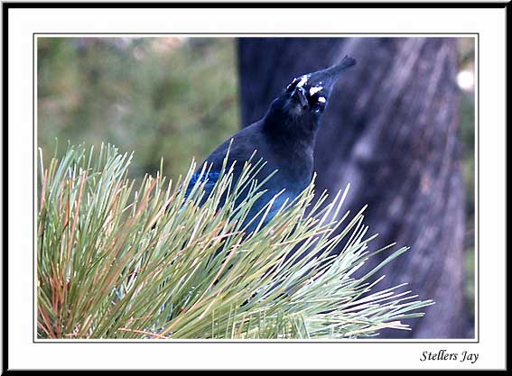
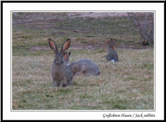
After driving back we walked to do our last trail of the day which was at least double the 1 mile it was supposed to be. On the way we saw Jack Rabbits (the ones with really long ears) and some very odd birds sitting under the bushes. They didn´t even move when we walked passed!
After pasta for dinner we wrote the computer diary and our legs knew that we´d walked 10 miles today! We´ve done everything there is to see at Kodachrome so now we can move on!
19.11.2003: Kodachrome Basin SP - Upper Calf Creek Falls
This morning we had to wipe Winnie down as the ice started melting and we had a bit of condensation inside. After showers and breakfast (doughnuts!) we tidied up, and got ready to drive off. We filled up with water before driving 43 miles to Escalante to pick up info from the visitor centre.
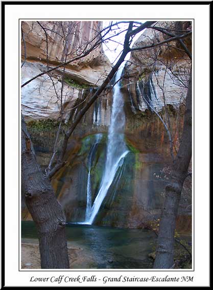
After having a pizza for lunch and buying some second hand books for $2 each, we drove further along the scenic highway 12 to Calf Creek. We got there at 2-45pm and knew that the 6 mile round trip walk up to the falls and back would take us 2 to 3 hours. So we had to get a move on if we were going to get to the falls and back whilst it was still light.
We set off at a good pace and it was a super walk along the creek, surrounded by steep red and yellow mountains either side with sheer faces and lots of caves. It was quite warm and sunny again today. We got to the falls in 1 hour! And they were well worth the effort. We slowed down for the way back which took us 10 minutes longer!
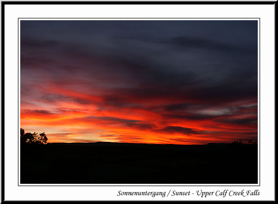
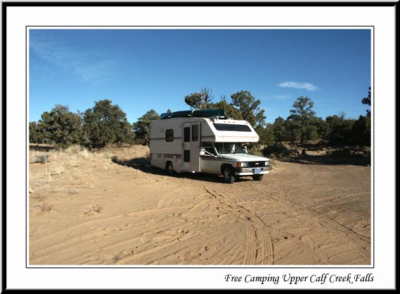
We decided not to stay overnight at the campsite where we´d parked as it cost $7 for no facilities. So we drove on the long, winding road up to see a great sunset from the top. After stopping for a photo, we saw a car driving out onto the road from somewhere on the left and decided to take a look. It turned out to be a perfect spot to park up for the night! We found out the next day that it was actually the trail head car park for the Upper Falls!
After cooking curry for dinner, we played cards and Helen lost!
20.11.2003: Upper Calf Creek Falls - Escalante
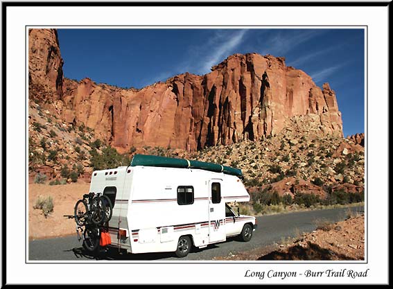
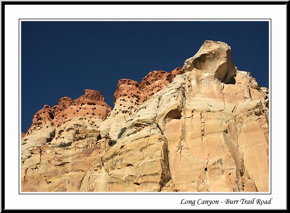
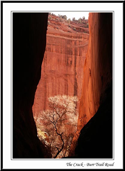
We got up at 9am and then drove further along the scenic highway to Boulder and then drove along the Burr Trail which is a paved road along a canyon - super. We found the "Crack" on the way back as we missed it the first time. Basically it´s where there is a crack in the rocks.
Burr Trail Road through Long Canyon.
Then we drove back to Boulder and went to a restaurant for lunch where the cook told us that we´d actually parked up at the Upper Calf Creek Falls last night and said we should do the walk to the falls. So we drove back and went on the very steep downward trail to the waterfalls. We tried to find the spring where the waterfalls originate, but somehow missed the past which was quite easy to do! We ended up climbing up quite a way and decided to turn around and cut across rather than going all the way back down and then climb back up again. Fortunately we managed to find the trail again because the cook had also told us to look back as we started the trail and make a note of the tree where the trail starts. Good job we did that because it ensured that we didn´t get lost! ( Also easy to do!)
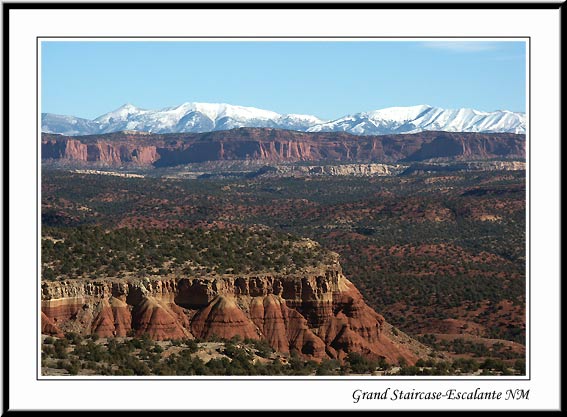
We walked for nearly 2 hours in the hot sun and up/down the 40 percent hill! We´re definitely keeping ourselves fit! Then we drove back to Escalante and went to the library to check our emails - loads of them! We had to leave at 5 pm as the library closed for 1 hour. So we went to the campsite, paid for our spot so we wouldn´t get woken up by a ranger! And then had showers and a salad for dinner. Then we drove back to the library and downloaded the CD onto the website to update it with our latest reports. We checked the weather for Zion National Park, our next destination, on the internet and found out that it would be -8 degrees on Saturday night and colder on Sunday!! Oh well, we can´t have it all our way!
21.11.2003: Escalante - Zion NP
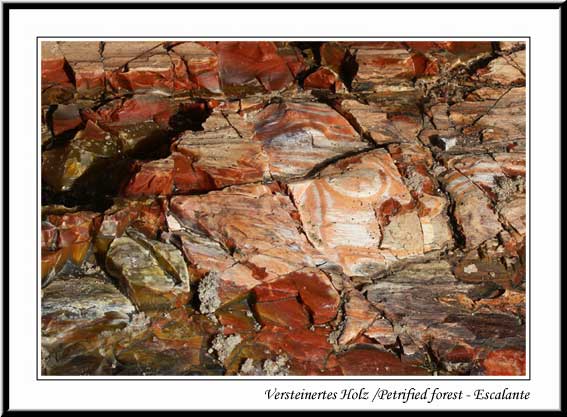
After breakfast, we went on a one and a quarter hour walk along the Petrified Forest Trail. There were large chunks of petrified wood that had taken on the colours of the minerals - almost in a rainbow formation, and mostly reds, oranges and dark yellows.
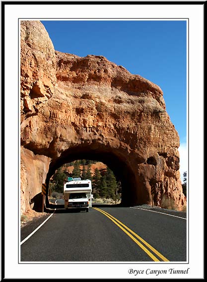
Once we got back we had some sandwiches, dumped our dirty water and then drove back along the scenic highway 12, back past Bryce Canyon and took a photo of Winnie going through one of the tunnels. Shortly afterward we got to the junction where we had to decide which way we were going to drive to Zion National Park. The East entrance, closest to where we were, has a height and width restriction which we didn´t think Winnie would fit through. Michael and Michel had said that Winnie needed 12 feet clearance, 13 feet to be safe. The tunnel had a height restriction of 11ft 4, width 7ft 10.
Well there was only one way to find out! So we pulled over to the side of the road and measured Winnie! We got a few strange looks from passing motorists! We found out that Winnie is 9ft 5 (with a few extra inches allowed) and 7ft 9 wide - just one inch to spare, so we thought we´d try breathing in! So, with a relieved smile on our faces, we headed for the East entrance which would mean saving 60 miles of extra driving to get round to the other side.
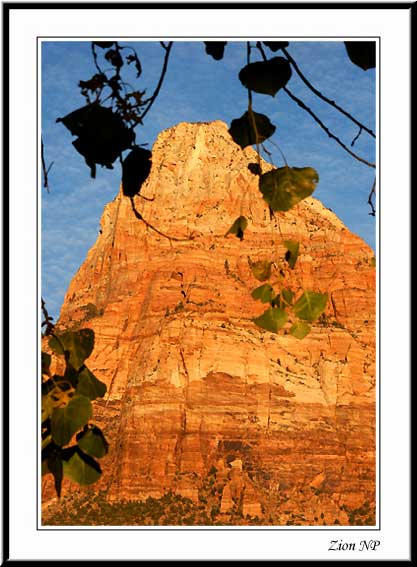
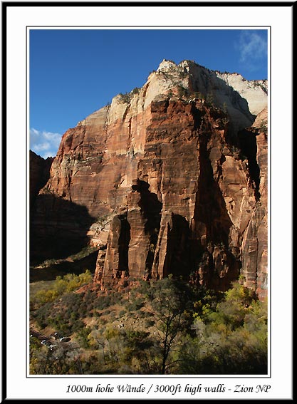
We got through the park gate and were rewarded with superb views of the canyon as we drove along the winding road. We stopped off at a car park and did a 1 mile walk to the canyon lookout, for superb views from above the canyon, the famous tunnel and the switchback roads that we would be taking after the tunnel, down the other side. Needless to say, we got through the tunnel without any problems at all, we even had plenty of width room.
Drive into Zion National Park.
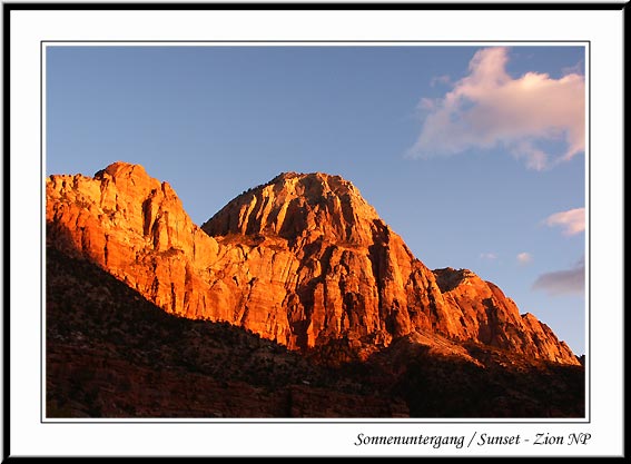
After a quick stop at the visitor centre to find out it was going to be -8 degrees tomorrow night!, we parked up at the Watchman campground - no showers, but electricity. We made something to eat and then Kirsten did the photos on the computer and Helen wrote the diary and read. Fortunately, we have our electric heater otherwise we wouldn´t have survived!
22.11.2003: Zion NP
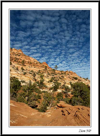
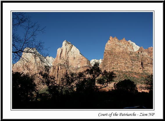
We had cheese on toast for breakfast using our electric toaster - well you have to take advantage of the electricity when you have it! Then we drove along the scenic drive into the heart of Zion National Park. During the main season, the road is closed to private vehicles and there is a shuttle bus service. But of course we´re out of season so we could drive along it.
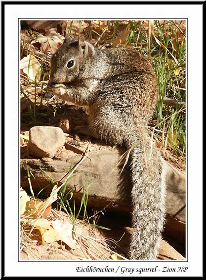
We did a total of three trails - the Lower, Middle and Upper Emerald Pools (2.5miles), riverside trail (2 miles) and then the Hidden Canyon Trail, very steep, overhanging cliffs and scrambling over rocks (2.5 miles). The riverside walk was the easiest and we met a squirrel who posed for the camera! The hidden canyon walk was really good but very steep. Fortunately, they had put chains along the rock face for us to hang on to as we sidled past a very steep drop on the other side! We also had to scramble over rocks and it was quite an adventure seeing how far we could get up the canyon.
We were quite tired afterwards and drove into a town just outside the west entrance to the park to do some shopping. But when we saw a Chinese restaurant we suddenly didn´t feel like cooking! It was quite busy in the restaurant which is a good sign. Afterwards we went back to the campsite and got our heater out - it certainly did get to -8 degrees!!